Monday, June 30, 2008

Golden Summer Days


There is something special about paddling the boat you built, with the paddle you carved, on a lake you love. They all came together for me yesterday on a golden summer day.

Sunday, June 29, 2008

Stories of Northern Leaders Series


Much has changed in recent years in the Canadian Arctic. This is especially the case surrounding the creation of Nunavut, the new territory which was carved out of part of the former Northwest Territories. Several Inuit were responsible for this happening and gradually the series of books called 'Life Stories of Northern leaders' is bringing their biographies to light. The latest to appear is on Peter Ittinuar. Here is part of the press release regarding the book's launch...

La biographie de Peter Ittinuar intitulée "Teach an Eskimo how to Read..." est enfin publiée. C'est le quatrième volume de la série "life Stories of Northern Leaders" et il est disponible auprès de Lise Fortin ( Fortin G ) au coût minime de 25$. La couverture attachée à ce message vous donner plus de détails sur le contenu du livre.

Les histoires de vie d'Abe Okpik et de John Amagoalik ont déjà été publiées dans la collection, celle de Paul Quassa et James Arvaluk devraient sortir sous peu).


If your French is a bit shakey, then it's interesting to note that this title is the fourth in the series following biographies of Abe Okpik and John Amagoalik. Two more are in the works on Paul Quassa and James Arvaluk and will be out soon. All can be obtained from Lise.Fortin@CIERA.ULAVAL.CA at Cdn$25 each. If you're at all interested in the development of Nunavut and its 'Fathers of Confederation', these people are ones to read about. They changed their world!

Saturday, June 28, 2008

Herbert's Fish 'n Chips

One last thing before I leave the Killarney area...


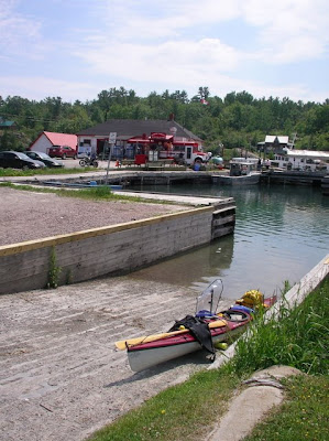
No visit could possibly be considered complete without somehow visiting Herbert Fisheries' Fresh Fish and Chips bus right on the dock near the public wharf. I was able to 'park' on the town boat ramp and get my fish 'n chip 'fix' as I paddled through town on my return from Baie Fine.

It isn't that obvious in the photo, but the reason these fish and chips are so worth the trip to Killarney has to do with the freshness of the fish. Tied to the wharf behind the chip bus, which you can see in red, is the boat that catches the fish. Fresh fish, hot batter and chunky chips all go together with the friendly service to make this place beyond belief. If you've just come in from a long paddle, there's nothing in this world that's as good!

Friday, June 27, 2008

Killarney Park - Baie Fine

This posting is a continuation of the previous three about paddling around Philip Edward Island in the Killarney area of Georgian Bay. Having completed the island tour, I returned to the Park put-in to re-adjust some of my equipment (left off some surplus-to-needs items and picked up my pump which had been left behind. I then set out for the town of Killarney and Baie Fine.


A day later, I camped about half way up the fjord-like Baie Fine and the following day took off for the 'Pool' at the very head of the Baie. I'd sailed in this area years ago, but never had the time to more than peek into Baie Fine, so reaching the Pool was a long held goal. I was excited to see this long sought spot!


Leaving my camp intact, I crossed to the opposite shore and followed the white hills with their tree speckled covering until I reached the narrows. At this point, the Baie closes in on itself and becomes a quarter of its width.


Lunch time had me hauled out on a pink granite 'beach'. I'd made it to the Pool, the quiet ring of water at the head of Baie Fine. I could see why so many boaters set this place out as a destination. Surrounded by high hills and dense forests, it's tranquility was total. I visited a small pond created by beavers just a few feet above the Pool. After lunch I paddled around and examined the shores for signs of other wildlife. I saw nothing, but birds of all sorts.


The paddle back to the camp I'd left setup from the night previous turned into a race against a thunder storm moving in from the west. Just as I made it into my tent, the rain came pouring down and lasted for several hours before clearing.


The skies cleared again in the evening giving me a sunset view up the Baie as I cooked my supper. As I took in this scene, a beaver came out of the wood not five meters from me dragging a freshly cut alder branch to the water's edge. There it began chewing off all the smaller branches one by one. Finally satisfied with its work, it entered the water and slowly circled. Suddenly it seemed to sense my presence. It slapped its tail on the surface in warning and plunged into the depths. A moment later it surfaced and continued to swim about, finally heading along the shoreline, out of sight.

Thursday, June 26, 2008

Philip Edward Island - Part 3


With a light offshore breeze, the following day was perfect for paddling the Georgian Bay coast of Philip Edward Island. An onshore wind off the bay makes this shore a dangerous one as it's cluttered with rocky islets and shallows.
Not only is navigation difficult thanks to the incredible number of similar islands, but also the chances for being smashed into one of the thousands of hazards is very high. One would think it was possible to take refuge behind the outer islands, but in many cases this doesn't seem to be much of an advantage as one is forced into more and more shallow water. Needless to say, I kept a close watch on my charts and foredeck compass to try and make some sense of where I was!

I slowly worked my way along the coast, marveling at the variety of colours found in the rocks along the way. All had been smoothed and polished by ancient glacial action. In many places it was still possible to see the gouges made by the glacier as it slip over the surface on its southern drift.

Eventually, the white quartzite hills of Killarney began to appear through the islands. I was getting closer to phase two of my trip: Baie Fine, a long fjord-like stretch of water which ran for miles into the hills of Killarney.


I passed through the narrow channel in front of the town of Killarney and from there westward into Lansdowne Channel. Here I set up my second campsite just outside of Rat Portage Cove. I actually checked out the portage as it would have cut many miles off my trip. Part of it has been paved! Somehow, that seemed a bit too tame, so I elected to paddle around via the 'Hole in the Wall' gap, a place I'd been before on several other trips, including the paddle around Manitoulin Island in 2004. (A kayaker I met a few days later told me he had dragged his plastic Necky over the portage and found it very usable)

I managed to recharge my cell-phone during lunch at the 'Hole in the Wall'. I was also amused to discover my old tent site had mysteriously turned into a bed of white flowers. Now how strange could that be?


The crossing of several miles over to the entrance to Baie Fine went smoothly in spite of a brisk cross wind from the west. Waves were just at the breaking stage, which made things interesting! The good news was the same wind pushed me rapidly along Baie Fine and to the next campsite above, perhaps the nicest spot I stayed at during the whole trip.

Wednesday, June 25, 2008

Philip Edward Island - Part 2


Above is a Google view of my trip route, beginning with an eastward leg up Collin's Inlet to my first camp in Beaverstone Bay.


Finding the entrance to Collin's Inlet can be tricky until you make the adjustment between the chart scale and the various features around you. I initially misjudged the scale and headed too far out into Georgian Bay only to become confused trying to locate what I could see around me with the features on the chart. I returned to my last known point, spent a few moments identifying the various islets etc, and then set off in the right direction.


While the day began in sunshine, it slowly turned foul as I paddled further down the narrowing channel in the Inlet.


In no time the rain was pelting down... The 'post' on my deck is my Sticky Pod which holds my video camera so I can film hands-free.


Once I arrived at the eastern end of Philip Edward Island, the rain ended, the skies began to clear and I could see the opening to Georgian Bay ahead of me.


Twenty eight kilometers of interesting paddling brought me to my first campsite of the trip on this little islet in Beaverstone Bay. While the rock looks hard and uncomfortable, in fact, I was quite pleased with the warm, smooth surface and enjoyed my stay in such a beautiful area!

Tomorrow's post will take us westward towards Killarney and Baie Fine.

Tuesday, June 24, 2008

Philip Edward Island - Part 1

Killarney Provincial Park is located in the northwest corner of Ontario's Georgian Bay. It is a land of contrasting rocks, red granite, white quartzite and grey limsetone all over lain with a scattering of pine and oak forest and crystal lakes. It's one of Canada's paddling paradises. Leaving my car at the campground's put-in located on a small stream leading down to Georgian Bay, I decided to first paddle around Philip Edward Island just east of the Park. The island is about 20 miles or so long and roughly 10 miles across at the widest point.


The boat ramp at the Park's put-in.


The stream to the Bay meanders around a bit alternately revealing banks of alder bushes and pink granite bluffs.


At the mouth of the stream, one is suddenly presented with a maze of islands, some bearly above water, others, like this one, high and topped with wind-blown evergreen tree, the trademark of Georgian Bay.


As the sun was out and the wind was up, I decided to head out into the Bay to play in the waves and warm up the muscles for the 2o mile paddle ahead of me. I was soon lost among the dozens of islets all around! Good map and navigation skills are definitely an asset in this area. Finally oriented once again, I headed into Collins Inlet, the narrow channel which cuts Philip Edward Island off from the mainland.

Monday, June 23, 2008

MEC's Toronto Paddlefest 2008


First stop on my recent jaunt was PaddleFest, an event put on by Canada's Mountain Equipment Coop chain in various cities across the country. I chose to head up to Toronto to meet Justine Curgenven and Dubside, not to mention anyone else who wanted to smile back in my direction.


It was a happy gathering of the water world. Water craft of every description were out on the bay enjoying the day, the boats and the instruction. I ran into Dubside, caught up on his news - he's incredibly busy these days - and we discussed his latest video production, a sort of history of Greenland paddling and Delmarva for the past several years.

Justine was as charming a person as you could ever hope to meet. We watched, listened and interrupted as she led us around New Zealand's South Island. It was a story on her blog account, but to hear her tell it, it was so much more. Truly a grand adventure!

After a fun-filled day, I headed northwards to Killarney Provincial Park for my own little adventure. I'll spend the next few days showing you what I saw there.

Wednesday, June 11, 2008

Ckayaker in Mexico?


Footprints found in 2003 in Mexico have recently been re-dated to about 40,000 years BP. The fact that they were found along the shores of an ancient lake also strongly suggests that the footprints belonged to early Inuit tourists wintering at one of the Mexican kayaking resorts probably popular back then. From the look at the prints, together with my newly acquired knowledge of muddy footprints, their depth and so on, I'd be prepared to say they were Inuit carrying one of the heavier Canadian style kayaks rather than the lighter Greenland version.

So it's good to know that early Canadian Ckayakers opened the door for me to visit Mexico - 'La terra del Dios' - in the distant past! No doubt I'll be welcomed back to the same paddling spots with open arms and cold cerveza, of course. Like many of you, I've often wondered why the word 'gringo' sounded like a corruption of the word 'kayaker'. Now I know! Science is so cool.

Friday I hit the road on my first paddling trip of the season. Expect posts to drop off until/unless I find internet in unexpected places...

Sunday, June 8, 2008

Getting Old...


Or maybe it was the heat, which with the humidity soared from about 15°C on Friday to over 33°C yesterday and again today. Either way I couldn't figure out how I was going to paddle in either my drysuit or my Reed gear. Then it hit me. Why were other people swimming and I was still wearing full immersion gear! Hello, Michael, it's nearly summer!

So today for the first time this year, I braved it, went paddling in swim suit and short sleeved top and my new funny sun hat. Then I too went to a swim. I'm getting old I guess... Next year I'll get younger and be more on the ball when summer strikes suddenly.

Wednesday, June 4, 2008

Muddied Decision Making


Just when I'd finally made some decisions on where and when I was going to paddle this spring, my contractor called and suggested a date he'd be free to do some work on the foundation to the house which has been pending for a while now. He promised me three days, "probably less", to get the job done. What could I say? Let's do it!

Then the rains came... This is day three of almost continuous downpour. The picture says it all. The job is finished, but how can I leave this mess behind? So it's back to decision time: when and where to paddle? It's looks like I'll leave next week after I've had a chance to get some grass seeded on this mess. First I'll head up to Toronto to the PaddleFest event and meet Justine Curgenvan and Dubside. Then it's west to Killarney and on into the North Channel area where I used to sail. I'll follow that up with a Greenland event on the Hudson River.

I figure this couple of weeks or so of fresh water paddling should whet my appetite for the East Coast in July!

Sunday, June 1, 2008

The Banner Pictures

Ever wondered where the pictures in the blog banner come from? I didn't think so, but I'll tell you anyway. Nothing like a bit more useless information to pad the far reaches of your brain. Think of it as brain padding when you're practicing your rolls. A little extra to keep the noggan in place...

Okay, from left to right, Florida. If you paddle inland from old Homosassa on the west coast, keeping to the right you'll pass under a small road bridge. Turn left and there's a little creek which follows the road. A little wild spot almost in town!

Second picture was taken on Trinity Bay heading south along the coast towards Hant's Harbour. We'd already paddled downwind that day, but it was so lovely out, we heading back upwind ending in Capelin Cove.

Middle picture was taken on a symmetrical day where shorelines and sky were all perfectly reflected in the waters of Lake Massawippi where I frequently paddle.

The next along is a beach just past the South Point coming out of Bonne Bay in Newfoundland. There's a waterfall and a hole in the rock at the beach making it a fun stop when paddling in that area.

Lastly, the new ribbing on my skin-on-frame qajaq. Here I've clamped then in place to get an idea of how I like the lines before I notch them in place.

Now that's done, I'm toying with posting up a new set...