Wednesday, August 15, 2007

It Was a 'Bergy' Good Year!

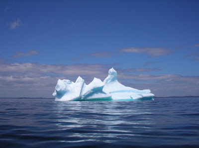
Everywhere I went along the north and east coasts of Newfoundland, people remarked that 2007 had been a "very good year" for iceberg sightings. Here is a small sampling of the many I came across...

Eastport Bay off Sailor's Island.


St Chads, off Baker's Loaf Island seen on right.


Off Bonavista in Bonavista Bay


Entrance to Joe Batts Arm, Fogo Island


Looking out of Cottrell's Cove, Notre Dame Bay


Twillingate, Notre Dame Bay

Sailor's Island - Part 4 of 4


This last video completes the series on our visit out to Sailor's Island. Rick and I had been trying to get out to visit at least one of the icebergs we could see from the shoreline near his cabin in Eastport. Each time we headed out, the winds conspired to keep us from getting close. This one near Sailor's Island was more accommodating: we had both wanted to visit the island since the previous summer, the weather the day we made the paddle out was sunny and calm and the iceberg couldn't have been more welcoming and beautiful. Changing weather the following day resulted in it's eventual breakup. It simply disappeared overnight. All that remained were a few 'bergy bits' rolling on the shores of Eastport Bay.

Tuesday, August 14, 2007

Sailor's Island - Part 3

Here is the third part of the video I made of Rick and my paddle out to Sailor's Island, an old re-settled community near Salvage, Newfoundland. In this episode, we paddle into the harbour for a look around and to take some pictures. We then leave to head out to look at the iceberg seen in the pictures posted yesterday.


Tomorrow's video will be the end of the series: the visit to the iceberg!

Monday, August 13, 2007

Sailor's Island, Newfoundland


We landed on the tiny beach in the protected harbour of Sailor's Island and started exploring. The first thing we noticed was a willow tree, just above and to the left of our kayaks, which seemed out of place. Perhaps it had been planted by residents years ago. An area just beyond seemed squared off and may have been a garden.


From the water, we could see the summer inhabitants: a flock of sheep, including a black one! It appears that someone has solved their fencing costs by moving the animals onto an island! We also caught sight of the iceberg in the bay beyond and decided to go out for a closer look. I'll post the video of that excusion in the next few days.


Rick went over to look at the area where we'd seen the swell breaking on the Bonavista Bay side of the island seen in part 2 of the video series. There were several hazards lurking out there for the unwary paddler. We decided it was just as well we didn't go out through the narrows after all. The ground was covered with lots of bakeapple berries slowly ripening. Perhaps they'll pick them in late August when they pick up the sheep.


Returning to our kayaks, we left the harbour and paddled past these lobster traps, then headed around the island and out to the iceberg. It was melting rapidly in the sunny warm weather, water came streaming down its sides and bergy bits trailed off to one side as they broke off and sailed away.

Friday, August 10, 2007

Sailor's Island - Part 2

In part 1, posted yesterday, Rick and I made the passage from the mainland over to Sailor's Island in Eastport Bay. Today, in part 2, we begin our exploration of the island, particularly the eastern entrance to the old harbour area.


To be continued...

Thursday, August 9, 2007

Paddle To Sailor's Island - 1

Sailor's Island is a small island a mile or so offshore in Eastport Bay, just around the corner from Salvage on Bonavista Bay in Newfoundland. It was once the site of a tiny fishing community which like Ireland's Eye was re-settled some years ago. Today little remains on Sailor's Island except for some grave stones, foundations and hints of old gardens and so on. Most of the houses were either floated over to Salvage or torn down. Still it is an interesting place to visit and explore as you'll see. Over the next few days, I'll post a series of short videos I took during the visit Rick Hayes and I made to the island last July. Hope you enjoy!


Part 2 will be posted tomorrow...

Wednesday, August 8, 2007

Trinity, Newfoundland

You've arrived in the community of Trinity on the bay of the same name for a little paddle. It's a town full of history going back to the days of fishing schooners and the Labrador fishery, iron men and wooden boats. It's a great place to paddle, especially if the weather's fair and you wish to get out and see whales, caves and, this year, icebergs.


So you look around for a place to unload your kayak and gear. Where's the put-in? Can you see it in the picture above? You'll have to look carefully (or click on the photo to enlarge it). You won't be alone out on the bay. There's an outfitter who uses the same beach for running kayak tours.


Okay, now park the car. Does it matter where? Not really, as you can see from the next picture. Four cars found a quiet vacant spot...


Now you're on the water. There's lots to see and do. Whales, sea caves, icebergs, the open waters of Trinity Bay and closer to those cliffs, lots of clapotis effect if that's your thing. Heading deeper into the harbour there's a mussel farm where you can practice your slalom skills using the floats as 'posts'. Enjoy your paddle!

Tuesday, August 7, 2007

Unsettled Weather

I had been looking forward to visiting a few of the places in Newfoundland where people used to live until recently. Many of these old 're-settled' communities were out on islands close to the fishery and thus provided an advantage years ago. As the way of life changed when the fishery declined many of these places were abandonned, some willingly, some not so.


The Kayak Newfoundland and Labrador Club had planned a 3 day paddling trip out to one such community on Ireland's Eye, an island on Trinity Bay in July. I was looking forward to meeting some local paddlers and visiting the island to get a feel for what life there must have been like years ago. The put-in was at Old Bonaventure seen in the picture above. I headed down there the Friday before the launch. It was a miserable day, rainy, wind, fog with heavy seas pounding outside the cove. Clearly, the trip would be put off unless a miracle occurred. And, can you see that lovely iceberg? Getting out to it would have really iced the cake! I wasn't a happy boy...


I had planned to camp in the cove overnight, but the foul weather forced me to retreat into nearby Trinity and a warm, dry B&B. The next morning, the weather had not changed. If anything, the winds had increased. The trip was off. Fortunately I did get to meet a number of club members on subsequent paddles here and there. I discovered they are a lively and very competent bunch with lots of stories to tell of their paddling exploits as well as other paddlers they've been out with, both Newfoundlanders and others like me, from 'away'.

Monday, August 6, 2007

Newfoundland Kayaks


As one would expect given the possibilities the coastline and numerous lakes (often called 'ponds') present to the paddler, Newfoundland has several local kayak builders. While heading up to Twillingate, I saw this sign and decided to check out what was happening in Cottlesville. The community isn't very large and I soon spotted this rack of boats on the lawn of a small house. I stopped and knocked on the front door.


Lindy Rideout and his dog answered the door and we spent some time talking about the boats he makes. I was a bit surprised to discover that the 'factory' was in the garage behind the house and the 'employees' consisted of only he and his wife. Together they make between 50 and 100 boats a year depending on demand. The boats themselves look well made as you'd expect of a small family operation like this one. What particularly struck me was the flat mid section of the hull suggesting a boat that would like to surf down waves. The rocker would permit good manuoverability if playing in rock gardens is your thing. The large hatches seem to beg for an over-nighter or more if you're so inclined.


A week or so later, I spotted one of another local builder, Eastern Island Kayak's boats on the beach at Trinity, the famous old fishing village where ships used to depart for the Labrador. No one was around for me to talk with, but again the boat looked interesting and I would loved to taken it out for a spin.

Sunday, August 5, 2007

Summer Fun


One of the best past-times when we were kids was to pack a lunch and hike into the woods to a secret swimming hole and go swimming. It's fun to know that hasn't changed. While I paddled down the rocky coast with their mother, her two children, their father and several friends hiked the coast to their favourite secret sandy beach. The wind was at our backs as we surfed down the lumpy waves and rebounds. In no time we'd covered the kilometers to the beach and for fun began weaving in and around the shoals and reefs just offshore seeing how small a space we could slip through in our boats. Then suddenly the cove filled with laughing voices and in an instant, like seals, the kids all jumped into the freezing waters of Newfoundland! Good times live on!

Friday, August 3, 2007

Hiking in the Rain

The weather at Cape Bonavista turned back to wind and rain the following day and I ended up not paddling at all. Instead I went hiking along the shore of Trinity Bay. Here are a few pictures of what I saw...


Blue iris and the unknown (at least to me) yellow flower were often found together wherever I traveled in Newfoundland. I began to wonder if the official colours of the province ought not to be blue and yellow!


In the old days, domestic animals were often allowed to roam free and gardens were fenced in. Today, in most part of Newfoundland, the reverse is free. However one can get an idea of the old days near 'The Dungeons' near the tip of Cape Bonavista. There's a large area where horses, cattle and sheep all roam as though they were loose like in former times.


There are numerous puffin colonies along the cliffsides of the cape. These little guys were as busy as ever despite the wind and the rain than kept me moving along from place to place, stopping only for the occasional picture.

Thursday, August 2, 2007

Kinauvit?

There's no excuse anymore for those wishing to increase their kayaking skills by actually learning to speak the language of the original kayak builders! What better way to really wrap yourself into your favourite pastime than to be thinking in Inuktitut as you paddle.

Here's a quote from the recently available website that will make all this possible...

"Anglophones who want to learn the Inuit language can now do so with a computer, mouse and speakers, thanks to a newly launched learning website that lets learners hear the language out loud.

"Tusaalanga.ca, which was launched Friday, offers Inuktitut grammar and conversation lessons, thousands of sound files and a glossary of more than 600 terms. The lessons, which come with sound files, show learners how to engage in different kinds of conversation, from exchanging basic greetingsto describing one's workplace, and even explaining how one's hunting trip went."


By the way, the term tusaalanga means "let me hear it" and kinauvit means "Who are you?" in Inuktitut. Login at Tusaalanga and let your lessons begin! Ataii!

• • • •• • • •

Just a quick note to today's blog to let you know that Hadas and Tomer of Terra Santa, Israel, have completed their incredibly fast paddle around Newfoundland. Good to have them home safely!

Wednesday, August 1, 2007

Bonavistan Cautions


I was anxious to get out and paddle when I was in the Bonavista area. Both the cape itself, its cliffs, the squat lighthouse and the area called the 'Dungeon' on the Trinity Bay side of the cape made the place interesting and exciting. After a rainy day's drive, I found a room at a B&B near the historic 'Ryan Premises', old merchant stores near the waterfront. My room overlooked the harbour and some icebergs beyond.


As the rain had stopped and the sky seemed to be clearing, I headed out for a harbour walk and a bite to eat. The gentleman running the B&B cautioned me to be back around 9 pm. He'd be "Having a 'lunch' for the B&B guests," he said.

I wandered around, took some pictures of Cabot's boat, the Matthew, and the icebergs in the bay, found a fish and chip spot for dinner and finally headed back to the B&B. The owner was out on the front porch having a cigarette as the sun lowered itself into the bay. It had turned into a glorious evening.


"You planning to go paddling tomorrow?" he asked me having seen my kayak on the car. I was.
"Stay away from the cape, me boy." he cautioned. "Especially the Trinity Bay side. There's currents there. They're very dangerous. We had a lady paddler here last year. She'd come in at night after crossing Trinity Bay. Couldn't see a thing it was so dark. Just heard whales coming up around her. You paddle down into the bay that way." he said, pointing southward into Bonavista Bay. He kept shaking his head as he finished his smoke. "Time for that lunch. You won't go paddling up near the cape, now, will you?" He said one last time as he crushed his cigarette out.


Cattle with an iceberg view


The 'Dungeons'

We went into the kitchen where his other guests had also begun gathering 'round the table. From the stove he heaved a big pot to the sink and poured off the water. Bringing it to the table, I could see it was full to the brim with crab legs. We all sat down and he began to cut open the legs and toss them to us around the table. As fast as we could pick out the meat, he'd have another leg cut and tossed our way. We stuffed ourselves, as his wife served up tea. I wondered about his advice and about that paddler from last year.
Tuesday, July 31, 2007

Oh, the Pain!


Coming home from a paddling trip is always a bitter-sweet experience. While it's a good feeling to once again be back in the family fold, the fact is you're no longer pumping out the heady adventure hormones. Even a few days of adventure paddling can get you hooked on these drugs. Being home is having to fight withdrawl symptoms. So I'm in a de-tox mode as I face the reality of paddling on the 'ordinariness' of my local lake: no whales, no icebergs, no bald eagles, no salty spray, no soaring cliffs, no swell, no foamy explosions on rocky shores, no feelings of going down a never-ending coastline, in short, no fun...

But there is also no dry-suit, no clammy spray-skirt, no driving cold rain, no blinding fog... mmmm... maybe I can make it through this period after all! At least, if I can make it long enough for my VISA card to recover, I can head off once again! I just gotta hang in there and deal with the pain...

Monday, July 30, 2007

Bonne Bay Mouth


I turned around and headed back to the put-in. The wind was out to get me as I paddled out of Bonne Bay into the Gulf of St Lawrence. I could feel my limits would soon be reached. Waves had been building for a while and now they were beginning to break and roll down on me, something I don't like to be out in alone. Then I turned around again. I had a goal, a promise to keep that I'd made last summer. I could handle the conditions as long as things didn't deteriorate further. I headed out again and soon passing the rocky spire called 'The Pinnacle' in the picture above. One thing my boat likes is to go up-wind if I want to paddle it!


Once passed this point, the wind died away almost completely. I had been slogging through a wind funnel created by the high hills near the mouth of Bonne Bay. I dug in and was soon easily gliding on, knowing I would be able to get to my objective, a narrow falls on South Point. To visit the falls was a paddling promise I'd made the year before from the lighthouse near Rocky Harbour on the north side of the bay. I'd soon be there.


When the falls came in sight, I got a surprise: there was a hole in the rocky wall which formed the south end of the beach at the falls. It wasn't big, more of a window than an arch, but it was something few others had seen as most kayakers visiting Bonne Bay tend to stay within the inner bays.


I walked the length of the curved beach and looked back to the lighthouse. I doubt people are able see the falls this year as the present flow rate is considerably reduced. I wondered if a local kayaker I'd met in Rocky Harbour had managed to visit the falls. I'd forgotten to ask when we'd talked the day before.


It was a fun and satisfying visit. I like keeping little promises. To celebrate, I collected a small rocky souvenir and headed back to my put-in at Norris Point, using Gros Morne as my beacon.

Sunday, July 29, 2007

Bonne Bonne Bay!


When I visited Newfoundland in 2006, one of the places I knew I wanted to return to and paddle on was Bonne Bay in Gros Morne National Park. This UN World Heritage site has so many attractive qualities about it. For example, in the top picture notice the brown hill in the background. Called 'The Tablelands', it is actually a block of the Earth's mantle which has been thrust from it's usual position under the continents to being exposed on the surface. Little grows on it due to the nature of the rock. I was surprised to see snow still lying here and there on its flanks in July. Hiking its trails is an 'otherworldly' experience to say the least and well worth the effort.


Paddling in Bonne Bay is dominated by the 'Tablelands' on the south or by 'Gros Morne', a bald blob of a mountain on the north side of the bay. The water is protected from the sea winds blowing out on the coast, but can be subject to sudden blasts coming down from the hills, so one needs to be weather-wise. A drowned glacial moraine at the point where the bay divides into two sections, reduces the circulation of sea-water on one arm resulting in it being slightly warmer than the other arm which receives a full complement of chilly Gulf of St Lawrence water with every tide.


Streams tumble into the bay here and there...


Paddling along the cliff faces provided a never-ending close-up geology lesson.


Paddling close to the shore revealed a wealth of sea life including fish, sea urchins, jellyfish and starfish easily seen in the clear waters of the bay.

One cannot paddle for long in Bonne Bay without wondering what it's like on the coast. Tomorrow I'll post about my venture out into the territory usually reserved for the intrepid circumnavigators, the most recent being Hadas and Tomer from Israel, who I understand are only days away from finishing their trip in record time.

Saturday, July 28, 2007

Waterproof Video Cam


I was no sooner in Newfoundland when I heard that Sanyo had placed the first Hi-Definition waterproof video camera on the market. While I have more than enough waterproof videocams which I'm still learning to use properly, this new camcorder is very interesting. Not only does it shoot video in HD format, it also takes 6 mega-pixel stills at the same time.

For the time being I'll continue playing with my Viosport H20 waterproof lens setup and the handy Oregon Scientific mini-camcorder (which took the Capelin video on yesterday's post), but should my trusty old Pentax Optio-43WR fail, this Sanyo might be a likely replacement.

Friday, July 27, 2007

Capelin Anyone?

Tony Lee, a kayaker and member of the Kayak Newfoundland & Labrador paddling club, has a wonderful web site called Kayak the Rock where one can find hundreds of photos of paddling the coast of Newfoundland. On a recent paddle together with a number of other KNL members from Bellevue Beach to Rantem at the head of Trinity Bay, I took some video footage as we encountered thousands of capelin spawning on the beaches. At one point these tiny fish were rolling onto a few yards of exposed sand inside a sea cave and, well, things got out of hand, as you might expect given we were literally paddling more in fish than on water at times. Have a look...


Check out Tony's photos of this paddle outing on his Gallery. Be sure to check out his photos of other trips as well.

Thursday, July 26, 2007

Burgeo's Surprise


Of course, Burgeo is not all rain and fog. The pictures above and immediately below were taken on a brilliantly sunny day from the town's observation deck just a short climb across the street from the B&B where I stayed.


Coming into the harbour is the ferry which plies the south coast towards Ramea, the offshore islands and other places to the east. The B&B owners are working on two additional places for people to stay, one in Ramea and the other in François, a community to the east along the south coast. These ferry services from Burgeo open up the possibility of paddling the coast one way and then returning on one of the ferries! Tempting, isn't it?


Cradled in such a rocky land and seascape, is another of Burgeo's surprises: the glorious sandy beaches in nearby Sandbanks Provincial Park. This area is well worth the visit if only for the exercise one gets taking the numerous walking trails it offers. In past years the park has been used by kayak clubs as a training venue for which its variable attributes make it ideal.

I had been thinking I would camp at Sandbanks Park as the day I arrived it was beautiful, warm and sunny. However, the high winds and promise of rain and foggy weather ahead changed my mind and I'm glad it did. Staying at Newfoundland's B&Bs are often a special experience, a chance to meet local people, sample local foods and learn about life in the community. It's also a way to 'give back' as one can put a little cash into the communities one visits. This act is something that's becoming increasingly important as these places make the sometimes difficult change from an economy based less on sea resources to one more service oriented. I like win-win situations like these!

Wednesday, July 25, 2007

Paddling Burgeo


Once you paddle out of Burgeo, the urge to continue along the coast is almost overwhelming. The rugged shore line disappears into the distance ahead of you. Headland after headland, the treeless, barren hills, cliff-lined inlets, spray clad islands and the never-ending rhythm of the sea all conspire to lure you on. Trapped by its powerful pull, I tried to slip through a tiny gap leading from Bay de Loup into the next bay to the east. This break in the hills would save me several additional kilometers of paddling out and around the headland. As I approached the narrows and entered its confines, I could see the swell breaking in the rocky shallows at the narrowest point. With the timing of the in-coming swell different on each side of the gap, the surf that resulted was a bit too confused for my 'rock-garden' skill level to manage. I tried to catch the effect in the picture above, but the shutter delay conspired against me. All looks calm above, but a trap awaited...

I backed out of the channel until it widened enough to turn around. I'm just not a rock garden paddler, at least not yet! Perhaps had the tide been higher, the chances of getting through unscathed would have been better. Perhaps had I not been alone, I would have dared it. It beckoned so strongly, but then again, its timing looked tricky...


There was so much more to explore in the area. I headed several kilometers up the Bay de Loup inlet until I could see its head. Cabins dotted the shore. The bare rock hillsides were a geologist's dream, both in their formation and subsequent glaciation and weathering. In places, trees clung stubbornly to the slopes, somehow managing to live in such precarious a place.

The longer I stayed out, the more the weather continued to deteriorate. The clouds kept dropping lower and finally the rain began. Patches of fog started drifting here and there as the wind rose from off the sea to the south. It was time to break the spell, turn around and retreat back to Burgeo. Certainly the temptation to keep on going eastwards along the southern shore was strong. It's a fascinating place to paddle with so much to explore and enjoy, in spite of the reputation it has for foul weather. It's easy to feel the draw it has on you, urging you to keep paddling, to keep exploring. Time slowly disappears, responsibilities vanish into the fog... Paddling becomes everything.

Monday, July 23, 2007

All Good Things Eventually Come to an End


My paddling trip to Newfoundland has come to an end. I arrived home yesterday with some wonderful memories of experiences which I'll share over the next little while. Our planet is filled with interesting places to kayak, but few are as varied, challenging and heart-warming as Newfoundland. It is truly a remarkable place.

I stopped in St Andrews as I returned along the Fundy shore and stayed at the Rossmount Inn. This inn looks old, but is actually less than a century old. The original house had burned to the ground in the 1960's. The present building was built to replace it, using the same foundations and fireplaces. Many of the furnishings and interior woodwork was re-cycled from an 19th century hotel which was being torn down in St John, a city further up the Bay of Fundy. The dining room is the real treasure, where the food is locally grown either at the Inn's own gardens or from down the road at a nearby organic farm.


Behind the Inn an old carriage way was built years ago, leading up the hill to the top. The road was built by the original owners so they could take their friends on picnics at the smooth granite rocks at the top, where a 360° view of Passamaquoddy Bay and it's superb kayaking can be seen.

But this was my last stop. In future posts, I'll retrace my steps, looking at some of the places I paddled, hiked or experienced in some way.

Friday, July 13, 2007

Chance Encounters


I was in St Brides yesterday, thinking I would get out and see the gannets at Cape St Mary, however the fog was too thick to see a thing. However I spied these two interesting kayaks on the slip in the harbour...


...and these two interesting people in the local library using the public internet access. Tomer and Hadas, two paddlers from Israel on their way around Newfoundland. They too were frustrated by the wind and fog, but making the best of their shore time. They've been making excellent time, but now plan to slow down a bit and enjoy the south coast before they finish their trip in Cornerbrook.

Tuesday, July 10, 2007

Ferry Time


Traveling to Newfoundland by car means taking one of the ferrys which leave from Cape Breton, Nova Scotia. One service goes to Port aux Basques on the southwest coast, the other heads eastward to Argentia on the Avalon further east. I chose the shorter of the two passages to Port aux Basques - about 6 hours. The above picture was taken of the dock area in North Sydney, Nova Scotia. Cars and trucks are starting to line up. In a few hours they'll be onboard, heading across the Cabot Strait.


The interior of the ferry is huge. I'm not sure of the number of vehicles it can carry, but certainly one can see anything from motor-cyles to tractor trailors and everything in between.


From the passenger deck, one gets a good view of the seas in the Strait. Here the wakes disappears astern. It is interesting to think that more than one kayaker has made the crossing successfully. Usually their route has been via a small rocky islet in mid channel where the crossing can be broken into separate legs. To say this kind of paddling is only for the very brave and highly skilled is an under-statement!

Monday, July 9, 2007

Leaving Home

Setting off on this paddling trip, I purposely didn't make many fixed destinations. I just loaded up the car and headed eastwards with the plan to eventually end up in Newfoundland. The first day of driving took me into the state of Maine in the northeastern corner of the United States. This area is home to many seakayakers and interesting paddling spots, but I didn't stop. I crossed back into Canada near St Andrews and the Bay of Fundy. Then I stopped.


New Brunswick's Bay of Fundy coastline has some great paddling spots. On my recent trip along this coast, I began at the Maine border. As soon as you get to St Andrews, the wealth of inlets and tree covered, rocky islands begins. One could literally spend weeks exploring them all the while staying in inns and B&B's which line the shore.

The path leading to a typical put-in in the picture above is a bit further eastward along the coast at a small Provincial Park at New River. There is great parking and a protected cove to launch from. If the weather is not suitable for paddling, walking trails lace the point which juts out into the Bay of Fundy. Along the way, you'll come across an old homesite where a family tried to make a go of it fishing and farming for a living. Like many of these sites, it offered a marginal living mixed with considerable isolation, yet for many it was a toe-hold on a new start in a new land.


The picture above shows the coastline as the point juts out into the Bay of Fundy. On a warm, sunny day, it provides great paddling. An onshore gale, makes landings a less than easy endeavour given the multitude of rocky obstacles waiting to catch the unaware. On a calm day like the one in the picture, it's a great chance to observe the tremendous variety of intertidal sea life.

I could easily have spent more time on this coast, but other venues beckoned...